The second and third grade classes visited Pigeon River, Kohler Andrae Park and The Kettle Moraines over the last three months to make observations and work together in the classroom to research Wisconsin landforms, practice reading and writing skills, and integrate movement into their research. Through trips to area landscapes, each classroom brought their knowledge and questions back to school as tools for learning and extending by thinking critically about what they’ve seen.
The Pigeon River lies just through the backyard of the school and offers a wonderful setting to explore and practice observing in nature. Students noticed such things as how the water flows, how the land slopes downward toward the river and the sizes of rocks along the path and recorded them in their field journals. Mrs. Pasche’s class found rapids on the river that offered a lot of new vocabulary, “we learned about the cut bank, the point bar, eddies, erosion, and deposition all at this one spot!” Back in the classroom, students worked on visualizing that experience and writing about it with descriptive words. In Mrs. Pekarek’s class, students worked in partners, giving feedback to help strengthen their writing by making it more descriptive of the things they noticed at the river.

The dunes and the marsh at Kohler Andrae gave the students a completely different perspective of the land. Field journals in hand, students stopped along the cording and recorded observations about the landscapes. Why is there sand in the grass? How did it get there? In two trips to the State Park, they visited the slow-moving waters of the marsh, sandy dunes, grassy prairie and the Lake Michigan shore. At the Marsh, students were asked to complete a See-Think-Wonder thinking routine. The wonders of Mrs. Faul’s class “included why the land looked so different from the sand dunes, and how they could be so close together. We wanted to know how the marsh was formed and where it began and ended. These wonders helped to fuel research later on in the week.”

The similarities and differences in the landscapes of both places left questions that needed answering for all three classrooms. “The students have been reading lots of texts and articles to figure out how all the beautiful places in Wisconsin were made. This is the research part of our project. We noticed that glaciers played a big part in forming the land and now we want to find out more about glaciers,” Mrs. Pekarek noted in her weekly blog. Mrs. Pasche’s class wrote descriptive essays about the landforms at Kohler Andrae park, using adjectives and vocabulary they researched after the trip and read more about rocks and minerals in small reading groups: “To further our studies of Wisconsin's landforms, processes that shape land, and rocks and minerals, students researched the properties of rocks and sorted them into the 3 types. Small reading group books are also giving students background knowledge about rocks and minerals and glaciers.”
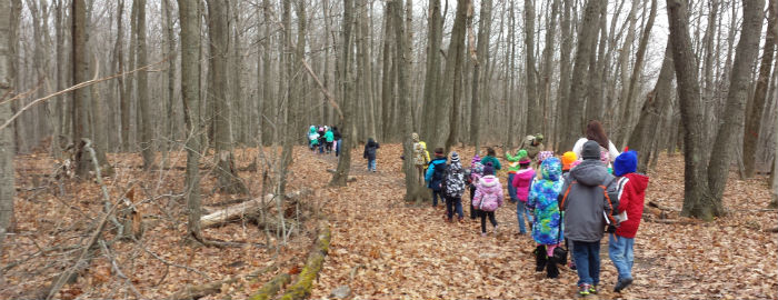
A few weeks later, the on a brisk, windy day in November, the three classes would have their chance to observe more evidence of glaciers. They braved the chill of our first snow and trekked along the trail of the Parnell Tower in the Kettle Moraines where it joins with the Ice Age Trail, a trail that is famous for its glacial beginnings. They’d come across different evidence of glaciers at Kohler Andrae, so they had some prior knowledge of how glaciers shaped the land. In the Kettles, they can see how it looks completely different from the lake, the marsh, or the river.

At one stop, they completed a Looking 10x2 thinking routine by finding a spot to sit and recording ten observations in their field journal. After a few minutes, they repeated the exercise from a new vantage point. Another stop, at the edge of the Greenbush Kettle Hole, students were asked to make a claim about this landform and support it with evidence in their journals. Students claimed that a glacier formed the great hole, and looked around for evidence from their research. At the top of the tower, students had a bird’s-eye view of the region they’d been researching and observing all trimester.

The thinking routines allow students to combine what they already know, what they see and how that makes them wonder. In this way, students make the connections between what they are observing in real-life landscapes and the research they’ve been doing in class about erosion, glaciers and weathering. Their own observations and questions guide their learning in the classroom and gives deeper meaning to the research of rocks and minerals, reading fiction and nonfiction books about geography.

At their Exhibition of Learning, students had the opportunity to share this learning with their families through various media. Each class created a movement piece choreographed to their recording of the poem "Wisconsin Destiny." They first created tableaus of the poem in Drama class, then reworked their ideas into interpretive movements about the landforms of Wisconsin. Families circulated through small groups of students who presented in more detail their explorations of landforms, their classroom research, painted reflections and thinking routines. This trimester, these second and third graders have a whole new outlook and understanding of how the land around them was created. One student explained that this learning changed the way she sees the land around her: "I used to think that Lake Michigan was just there, but now I know that it was made from glaciers. I had never thought about how a lake was made before."
